 SITEPLANS.CA
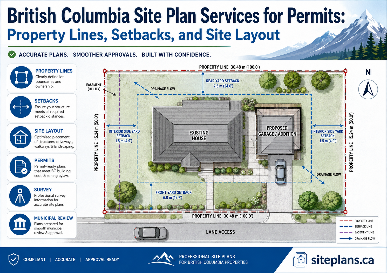
Need a site plan for a building permit in British Columbia? Whether you are planning a garage, deck, shed, addition, pool, carport, fence, retaining wall, patio cover, laneway house, or other residential project, your local municipality may ask for a clear drawing that shows how the proposed work fits on your property.
A British Columbia site plan helps show property lines, setbacks, existing buildings, proposed construction, driveway or lane access, drainage, trees, easements, services, and other site details that matter during permit review.
This guide explains what a BC permit site plan usually includes, why property lines and setbacks matter, how survey information can help, and what homeowners should prepare before submitting drawings to a municipality or regional district.
What Is a British Columbia Site Plan?
A British Columbia site plan is a scaled drawing of a property from above. It shows existing site features and proposed changes so the project can be reviewed in context.
A residential site plan may show:
- property lines and lot dimensions;
- existing house footprint;
- existing garage, shed, deck, patio, driveway, fence, or retaining wall;
- proposed project location and dimensions;
- front, side, and rear yard setbacks;
- lane access, driveway access, and parking layout;
- walkways, stairs, gates, and exterior access routes;
- lot coverage and hard surface areas;
- trees, landscaping, and tree protection areas;
- easements, right-of-ways, and encroachments if known;
- water, sanitary, storm, gas, hydro, and other services where known;
- grading, drainage direction, downspouts, swales, and catch basins;
- north arrow, drawing scale, address, and legal description.
The purpose is simple: a site plan should make the proposed project easy to understand. A reviewer should be able to see what exists now, what is being proposed, how close the work is to property lines, and whether access, drainage, trees, services, or neighbouring properties may be affected.
When Do You Need a Site Plan in BC?
In British Columbia, building permit requirements depend on the local municipality, regional district, project type, zoning, and property conditions. The Province of BC explains that building permits help ensure construction and renovation projects are safe, legal, and compliant with the BC Building Code and local regulations.
Official source: Province of British Columbia – Building or Renovation Permits
A site plan is commonly needed when a project changes the property layout, adds a structure, changes access, affects setbacks, or creates new roofed or hard-surface areas.
Common projects that may need a site plan include:
- new homes;
- home additions;
- detached garages;
- carports;
- decks and porches;
- sheds and accessory buildings;
- pools and hot tubs;
- fences and gates;
- retaining walls;
- patio covers;
- laneway houses or garden suites;
- driveway widening or parking changes;
- projects near property lines, trees, easements, slopes, or services.
Every local government can have its own forms, checklists, zoning requirements, and submission process. That is why a BC site plan should be prepared for the specific property and municipality, not copied from a generic example.
Why Property Lines Matter
Property lines are the foundation of a site plan. Setbacks, building placement, fence location, access, easements, and lot coverage all depend on knowing where the legal boundaries are.
A site plan may show:
- front lot line;
- rear lot line;
- side lot lines;
- lane boundary if the property has rear lane access;
- corner lot or flanking street boundary;
- irregular boundary lines;
- easement or right-of-way lines;
- fence lines if different from the legal property line.
It is important not to assume that an existing fence, hedge, retaining wall, driveway edge, or landscaping border is the legal property line. The Land Title and Survey Authority of British Columbia explains that a land survey represents the legal boundaries and dimensions of a surveyed parcel of land and identifies the monuments or survey posts used to define those boundaries.
Official source: LTSA – Land Survey Plans
If your project is close to a property line, a professional survey may be needed to confirm the boundary before construction begins.
Site Plan vs Survey Plan in British Columbia
A site plan and a survey plan are related, but they are not the same thing.
Survey Plan
A survey plan is prepared by a professional BC land surveyor. It can show legal property boundaries, lot dimensions, monuments, existing structures, easements, and other measured site information.
Site Plan
A site plan uses available property information to show the proposed project layout. It explains where the work will go and how it relates to the property lines, existing buildings, setbacks, access, drainage, trees, and services.
For many permit projects, a current survey or survey-based information can make the site plan more reliable. This is especially helpful when:
- the project is close to a boundary;
- the lot is irregular;
- there is a rear lane or corner lot condition;
- a fence may not match the legal property line;
- there are easements or right-of-ways;
- the municipality asks for a survey;
- grading, slopes, or retaining walls are involved;
- a new home, addition, garage, or laneway house is being reviewed.
SitePlans.ca can prepare a clear site plan from available property information, sketches, municipal comments, and project details. If a legal boundary must be established, that work should be completed by a qualified BC land surveyor.
Why Setbacks Matter on a BC Site Plan
Setbacks show how far the proposed work is from the property lines, lanes, streets, and other buildings. They are one of the first items many reviewers check because they help confirm whether the project fits within zoning rules.
A site plan may need to show:
- front yard setback;
- rear yard setback;
- interior side yard setback;
- exterior side yard setback for corner lots;
- setback from a rear lane;
- distance from the proposed structure to the existing house;
- distance to other accessory buildings;
- distance to fences, retaining walls, pools, decks, trees, or easements.
Setback rules vary by municipality and zoning district. For example, the City of Surrey explains that zoning bylaws affect what buildings are allowed, building size, permitted use, off-street parking, and setbacks from property lines.
Official source: City of Surrey – Zoning
Because every BC municipality has its own zoning rules, a site plan should show the actual distances from the proposed work to the property lines. Reviewers should not need to guess.
What Municipal Reviewers May Check
Municipal review varies across British Columbia, but many permit reviewers look for the same basic site information. The purpose is to understand the project location, confirm zoning and building placement, and check whether additional information is needed.
Reviewers may look at:
- property lines and lot dimensions;
- existing and proposed building footprints;
- project dimensions;
- front, side, and rear yard setbacks;
- lane access, driveway access, and parking layout;
- lot coverage or site coverage;
- impermeable surface coverage where required;
- trees and tree protection requirements;
- grading and drainage direction;
- retaining walls and slope conditions;
- easements, right-of-ways, and restrictive covenants;
- utility and service locations;
- whether additional professional drawings are required.
The City of Vancouver’s application forms and checklists page, for example, directs applicants to choose the checklists and guides that apply to the project, building type, and property zoning.
Official source: City of Vancouver – Building and Renovating Forms, Checklists, and Bulletins
What Should a British Columbia Permit Site Plan Include?
The exact requirements depend on the municipality, project type, zoning district, and site conditions. Still, most BC residential site plans include a similar set of core details.
1. Address and Legal Description
The site plan should include the property address and legal description if available. This helps match the drawing to the correct property and permit application.
Helpful details include:
- street address;
- legal lot and plan number if available;
- municipality or regional district;
- drawing date;
- drawing scale;
- north arrow.
2. Property Lines and Lot Dimensions
The drawing should show the full property boundary and lot dimensions. If the lot is irregular, curved, sloped, or located on a corner, the boundary should be drawn clearly.
Property-line information is especially important for projects near side yards, rear yards, lanes, easements, fences, or retaining walls.
3. Existing House and Structures
The existing house should be shown and labelled. Other existing structures should also be shown when they affect the project.
These may include:
- garage;
- carport;
- shed;
- deck;
- porch;
- patio;
- pool;
- retaining wall;
- fence or gate;
- driveway or parking pad;
- walkway, stairs, or ramp.
Reviewers need to understand the existing layout before they can review the proposed work.
4. Proposed Project Footprint
The proposed work should be clearly labelled. Use simple labels such as:
- Proposed Addition;
- Proposed Garage;
- Proposed Deck;
- Proposed Shed;
- Proposed Carport;
- Proposed Pool;
- Proposed Fence;
- Proposed Retaining Wall;
- Proposed Laneway House.
The plan should show the project’s length, width, footprint, and relationship to the rest of the property.
5. Setback Dimensions
Setbacks should be shown clearly. A reviewer should be able to see the distance from the proposed project to each relevant property line.
Setback dimensions may be needed from:
- front lot line;
- rear lot line;
- side lot lines;
- lane boundary;
- flanking street on a corner lot;
- existing house;
- detached garage or accessory building;
- easement or right-of-way boundary.
6. Access and Parking
Access and parking are important for garages, carports, laneway houses, driveway changes, additions, and projects that affect existing parking.
The site plan may show:
- front street access;
- rear lane access;
- driveway location and width;
- parking space location;
- garage or carport access;
- vehicle gate location;
- pedestrian access path;
- walkways, stairs, and entrances.
Many BC cities have properties with rear lanes. If the project uses a lane, the lane should be shown clearly on the site plan.
7. Lot Coverage and Hard Surfaces
Some municipalities review lot coverage, site coverage, or impermeable surface coverage. This can be important for additions, garages, carports, sheds, patio covers, pools, and laneway houses.
Coverage-related items may include:
- existing house footprint;
- proposed addition footprint;
- garage, shed, or accessory building area;
- carport or patio cover roof area;
- driveways and parking pads;
- walkways and patios;
- pool decks and hardscape;
- landscaped or permeable areas.
8. Drainage and Grading
Drainage is important because new structures, roofs, hard surfaces, and grade changes can alter how water moves across a property.
A site plan may show:
- surface drainage arrows;
- roof drainage direction;
- downspout locations;
- swales;
- catch basins;
- storm service route if known;
- existing and proposed grades where available;
- retaining wall drainage if applicable;
- areas where water should not discharge.
Water should not be directed toward the house foundation, neighbouring properties, steep slopes, retaining walls, sidewalks, lanes, or low areas where ponding may occur.
9. Trees and Landscaping
Trees can affect project layout, excavation, service trenches, driveways, and municipal review. Some BC municipalities have tree protection bylaws or arborist requirements.
A site plan may show:
- existing trees on the lot;
- street trees;
- trees on neighbouring properties near the work area;
- trees proposed for removal;
- tree protection barriers;
- landscaped areas;
- tree root zones if provided by an arborist.
10. Easements, Right-of-Ways, and Covenants
Easements and right-of-ways can affect where buildings, fences, sheds, pools, retaining walls, driveways, and service routes can be placed.
Known site constraints should be shown, including:
- utility easements;
- sewer or drainage easements;
- access right-of-ways;
- restrictive covenants;
- lane dedications;
- encroachments;
- shared driveway areas;
- service corridors.
Surrey’s zoning page notes that, in addition to zoning bylaws, property owners should check the Land Title Office for restrictions or charges such as design guidelines, easements, right-of-ways, and restrictive covenants.
11. Services and Utilities
Some site plans need to show services and utilities. This is common for additions, pools, laneway houses, new detached structures with electrical service, drainage projects, and projects that involve trenching.
Service details may include known:
- water service;
- sanitary sewer;
- storm sewer;
- gas service;
- hydro or electrical service;
- utility poles and overhead wires;
- catch basins and manholes;
- downspouts and stormwater routing;
- proposed service trenches.
BC Projects That Commonly Need Site Plans
Garage Site Plans
A garage site plan should show the proposed garage footprint, existing house, driveway or lane access, parking layout, setbacks, lot coverage, roof drainage, trees, and property lines.
Deck Site Plans
A deck site plan should show deck size, height if known, stairs, landings, setbacks, property lines, doors, existing house, and nearby patios, fences, trees, or retaining walls.
Shed Site Plans
A shed site plan should show shed placement, side and rear setbacks, property lines, existing house, trees, drainage, easements, and backyard access.
Addition Site Plans
An addition site plan should show the existing house, proposed addition, setbacks, lot coverage, services, drainage, trees, grades, and nearby structures.
Carport Site Plans
A carport site plan should show roof area, support posts, parking layout, driveway access, setbacks, roof drainage, existing house, and property lines.
Pool Site Plans
A pool site plan should show the pool location, safety barrier, gates, equipment pad, setbacks, drainage, pool deck, trees, overhead wires, and nearby structures.
Fence Site Plans
A fence site plan should show property lines, fence alignment, fence height, gates, corner-lot conditions, driveway visibility, sidewalks, streets, and lanes where relevant.
Retaining Wall Site Plans
A retaining wall site plan should show wall location, wall height, slopes, top and bottom wall elevations, drainage direction, boundaries, trees, and nearby structures.
Laneway House or Garden Suite Site Plans
A laneway house or garden suite site plan should show the existing house, proposed dwelling, access, parking, setbacks, services, drainage, trees, grades, easements, and relationship to the lane or rear yard.
Why BC Municipal Requirements Vary
British Columbia has provincial building rules, but local governments still administer building permits, zoning bylaws, development permits, tree bylaws, driveway requirements, drainage standards, and local application checklists.
This means a site plan for Vancouver may not be the same as a site plan for Surrey, Burnaby, Richmond, Victoria, Kelowna, Nanaimo, Abbotsford, Kamloops, Coquitlam, or a regional district.
For example:
- Vancouver uses project-specific checklists and bulletins;
- Surrey zoning explains setbacks, parking, permitted uses, and building size through zoning bylaws;
- some municipalities require tree protection information;
- some properties may need development permit review because of slopes, waterways, environmental areas, heritage areas, or form-and-character rules;
- some projects need survey, grading, structural, or professional documents in addition to the site plan.
That is why the best site plan is not just a drawing of the proposed structure. It is a property-specific layout that responds to the local review questions.
Common BC Site Plan Mistakes That Delay Permits
Many permit delays happen because the site plan is missing basic information. Avoid these common mistakes:
- not showing the full property boundary;
- assuming the fence is the legal property line;
- not showing lot dimensions;
- not labelling the existing house;
- not identifying the proposed project clearly;
- forgetting project dimensions;
- not showing setback distances;
- not showing rear lane or driveway access;
- missing parking information;
- not showing easements or right-of-ways;
- not showing drainage direction;
- forgetting trees or tree protection areas;
- not showing existing accessory buildings;
- not showing services when they affect the project;
- using a rough sketch that is not scaled or labelled.
What to Gather Before Ordering a BC Site Plan
Before preparing a site plan, gather as much property and project information as possible.
Helpful items include:
- property address;
- legal description if available;
- survey plan if available;
- photos of the property;
- sketch of the proposed project;
- project dimensions;
- distance from proposed work to property lines if known;
- location of existing house, garage, shed, deck, patio, driveway, pool, fences, and retaining walls;
- rear lane or driveway access information;
- tree locations if relevant;
- known easements, right-of-ways, or covenants;
- service or utility information if relevant;
- municipal comments or correction notes if already received;
- contractor, designer, engineer, or arborist drawings if available.
The more accurate the starting information, the more useful the finished site plan can be.
How SitePlans.ca Helps BC Homeowners
SitePlans.ca prepares clear, easy-to-read site plans for residential permit projects across British Columbia and Canada. Our goal is to help homeowners, contractors, designers, and permit applicants organize the site information into a clean drawing that supports municipal review.
Depending on your project, your British Columbia site plan can show:
- existing house and structures;
- proposed project footprint;
- property lines and lot dimensions;
- front, side, and rear setbacks;
- lane access, driveway access, and parking layout;
- lot coverage and hard surfaces;
- grading and drainage direction;
- trees and landscaping;
- services and utility routes where known;
- easements, right-of-ways, and nearby constraints.
A site plan is not a substitute for a legal survey, engineering, architectural design, zoning approval, or municipal review when those are required. But it is often the drawing that helps everyone understand the property layout before the more technical parts of the permit package are reviewed.
Need a British Columbia Site Plan for a Permit?
If your municipality has asked for a site plan, or if you are preparing a permit package for a residential project, SitePlans.ca can help create a clear, permit-ready drawing based on your property information and project details.
We can help with site plans for BC projects such as garages, decks, sheds, additions, pools, fences, carports, retaining walls, patio covers, laneway houses, garden suites, driveway changes, and other residential improvements.
Order your British Columbia site plan from SitePlans.ca
Final Thoughts
A British Columbia site plan is one of the most important drawings for many residential permit projects. It shows how the proposed work fits on the property and helps municipal reviewers understand property lines, setbacks, access, drainage, trees, services, lot coverage, easements, and existing structures.
Property lines matter because the legal boundary controls where setbacks are measured. Setbacks matter because they help confirm whether a project fits under local zoning rules. Site layout matters because a permit reviewer needs to see the full context, not just the proposed building.
Before submitting a BC permit application, confirm your local checklist, verify property information, show the proposed work clearly, and prepare a site plan that makes the project easy to review.
Official Sources
- Province of British Columbia – Building or Renovation Permits
- Province of British Columbia – The Building Act
- LTSA – Land Survey Plans
- Association of British Columbia Land Surveyors
- City of Vancouver – Building and Renovating Forms, Checklists, and Bulletins
- City of Surrey – Zoning
- City of Surrey – Single Family Dwelling Permit